Views from the summit of Mount Pulag February 2017

The summit of Mount Pulag marks the boundary of the provinces of Benguet, Ifugao and Nueva Vizcaya.


The mountaintop's breathtaking stunning views, spectacular vistas and magnificent sceneries, are complemented by easy accessibility. Hence, Pulag is now a most popular mountaineering destination, attracting tourists and climbers of varying abilities.


Step after step, a drop of sour sweat after another, hour after hour on sore feet– climbing a mountain is no easy
feat. But when you reach the summit, the gain makes it all worth the pain.

Yes indeed. It is well worth hiking up in the post-midnight to witness the darkness of night, slowly yield to the orange glow and then golden yellow, of daylight.

 |
| A ghost who walked. |

The yellow-orange glow of sunrise.
From the peak of Mt Pulag, the sunrise event on the sea of clouds horizon is simply awesome.
From the peak of Mt Pulag, the sunrise event on the sea of clouds horizon is simply awesome.

A phantom with what looks to be joyfully dancing tourists.

In recent years, the summit and its lower peaks have been visited
by around 20,000 boot-clad admirers each year.

These visitors, mainly tourists from the lowlands, come around
during the dry months between November and May. Social media has increased
visitor numbers markedly with so many people posting photos and blogs of the
mountain. Peer testimony and word-of-mouth also convince many people to climb Pulag.
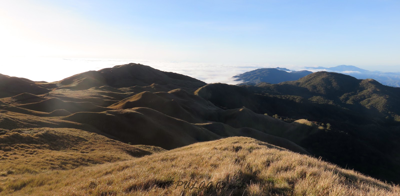
Mount Pulag National Park is a wonderland of natural attractions. The winding road trip to the site, the drive along the steep mountainsides and narrow valleys, the mountain villages, the terraced vegetable farms, the scented pine forests, the mossy montane forests, the sweetest springwater, and the grasslands around the summit - this is another world.

Witnessing the break of dawn and sunrise, the sea of
clouds, the mountain ranges near and far, the stars
constellations and distant galaxies in the crisp unadulterated night-time Pulag
skies – the experience is something else - a different universe.
 In the daytime: the pure white of cloud, the verdant bloom of forest, the brown of the earth, the cyan blue of the sky, the yellow of early morning sunlight painting the mountain tops, the scattered crimson splash of rare tree leaves, or the grey streak of a distant peak. This natural yet rare and glorious display of the full spectrum of the colors of the rainbow – this is the garden of the gods.

There is, however, a feature of climbing Mount Pulag that is
unknown to many a visitor. From the summit, one can look down on the main ranges of the Cordillera
mountains. Yet, although very prominent and visible from Pulag, few realize the privilege of sighting the peaks of the Cordillera range. Many look but do not know what they see. The marvellous sight of these many significant peaks, from the one vantage provided by Mount
Pulag, is unappreciated and wasted on most climbers.


This unknown bonus of
climbing Pulag is of course dependent on clear weather.
Many of the Cordillera
mountain peaks are well above 2000m, lower than Mount Pulag but quite rugged inaccessible
challenging. Each peak is worthy of a climbing expedition.

To the east, when the sea of clouds are drained
up into the atmosphere, are the lower hills of the towns of Tinoc to Ambaguio
to Kayapa.

North to amuyao


Tabayoc. Due north behind Tabayoc on the near range are: Abao and Napulawan
and Kapiligan.

Farther out are Data and Kalawitan.

Again Amuyao, on its own lonesome on the visible edge of the north sea.

Mountains to the south.The peaks of Akiki, Purgatory, Ugo, Ulap and Santo Tomas.

Mountains to the west are Ules, Timbak, Osdung and the other peaks in Kibungan and Bakun.

Looking west and zooming in.

Northwest to Buguias Mankayan and Tirad pass.

Mountains to the north and the northern sea, and all that some people see is their own selves.

How many times must a man look down/
before she can see the sea?
before she can see the sea?

Yes'n how many times can someone turn her head
And pretend that he just doesn't see?
And pretend that he just doesn't see?

In the far north are the mountain ranges in Abra, Mountain
Province and Kalinga. I can just make out my old haunts - my hometown playgrounds of Mengmeng (Bandilaan), Paras and Serkan - all at about 2300m elevation - the thin grey outline in the far background.


Out on the road that lies before me now
There are some turns where I will spin.


My guide Rita is a Vizcaya-Benguet born-and-bred, Ibaloi-Kalanguya mountain amazon.
This young lady is an awesome trail runner and camera shy - 'shy ma-ngo'. She led me up and down a mountain trail, and told me about many a mountain tale. When she's not tending her fields, Rita's got hikers eating dust from her heels.
Again southwards to Akiki, Purgatory and Ugo.

And Ulap and Santo Tomas.

To the edge of the sea.

Rita finally pauses and gives a smile for the camera (with Pulag at left of picture). She was bounding up and down the mountain trails, graceful as a Mt Pulag sambar doe. I was mostly sprinting just to keep up.

We left the mountain and its sign and marker behind. And as I looked back,
I terminator-ed my stay saying: 'I'll Bibak.'


Somehow I've learned how to listen
For a sound like the sun burnin’ on
In the magic that morning is bringing
There's a song for the life I have found
It keeps my feet on the ground


During the busiest times, normally around March to April, sometimes the locals perform rescue missions, mostly carried out to aid people in
trouble on the trails.

Most rescues involve
inexperienced, ill-prepared hikers who are heavily laden and kitted out with unnecessary accoutrements
and suffering from lack of fitness.

Visitors can avoid needing to be rescued by hiring a local guide.

The DENR requires a medical certificate of those climbing Pulag, but it is not able to verify the hiking fitness of each and every visitor. And anyone who wants to enter Mount Pulag National Park, is required to attend a DENR orientation. Visitors are briefed on the do’s and don’t’s, and the good precepts: i.e. respecting the mountain and its environs, the no-nos: camping, fires, noise, garbage, etc. Safety should likewise be emphasized. And if you are unfit for mountain climbing, do yourself (and your friends and others) a favor and stay home.

The mountain is goin’ nowhere, so please get
fit before going there.


Looking back at Pulag's bald summit - the playground of the gods.
Just like the sun over the mountain top
You know I'll always come again.