Illawarra Escarpment State Conservation Area

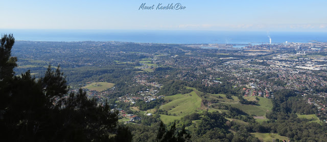
View from Mt Kembla looking southwest.
The Illawarra Range is comprised of fold cliffs
and outcrops of eroded plateaus. It stretches from Stanwell Park in
the north to the Shoalhaven in the south.

The escarpment was formed between 225 and 280 million years
ago. It settled to its present height around 30 million years ago.
To explore the escarpment there's a walking trail that starts either from Coalcliff (Wodi Wodi track) or Austinmer (Sublime Point track). The Forest walk starts with a climb before it winds along its leisurely 11-kilometre route. This extensive walking track is one of the region’s best. It offers great birdwatching spots and scenic views across Illawarra Escarpment State Conservation Area, to the panoramic Pacific coastline.


 From a lookout on the escarpment - overlooking the northern Illawarra Plain: Austinmer, Thirroul, Bulli, Wollongong up to Port Kembla in the far distance.


 From Mt Keira panning clockwise north-to-south from Brokers Nose to the Pacific to Port Kembla.
Mount Keira offers scenic views and a ring track for an easy walk or a test trail run. The track follows a lush parade of forests and terrain, from cool sub-tropical bush to lofty red cedars and rocky outcrops.


 Wollongong is a seaside city located on the narrow coastal plain between the Illawarra Escarpment and the Pacific Ocean.


 It might be time to visit Wollongong and the Illawarra again - and that Superb Lyrebird. And to do a side trip to the Escarpment.


The most extensive area of rainforest in the Sydney basin is
found here in the Illawarra Escarpment. The area is an important refuge for species
affected by development and bushfires. I spotted this gorgeous Superb Lyrebird on the
side of Cordeaux Road going up to Mount Kembla. My feathered friend was acting
playfully. It appears to be a juvenile.

On the South Coast Line, a railway bridge crosses Stanwell
Creek in Stanwell Park. There are old buildings, portals, rail tracks and other
historical features from the farming and coal mining heritage of this coastal
plain.

The Illawarra Escarpment offers a full range of exciting
walks. Several of the tracks weave through
magnificent cliff-top rainforest and dry eucalypts.

Coalcliff

The Sea Cliff Bridge (completed in 2005) was constructed out over the sea to bypass a dangerous section
of the Escarpment over the sea.

Most of the escarpment is sandstone, with the many protruding boulders
and ledges prominently visible.


Logging and coal mining gave birth to the many coastal towns adjacent to the Escarpment.

The Illawarra Escarpment area boasts important local
heritage, including colonial roads like the ones constructed through the efforts of surveyor-general Thomas Mitchell around 1834. Some were even built by convicts.
Nowadays there is a network of roads crisscrossing the Escarpment, finding every
conceivable route across and along the range.

Even powerlines get the blues (the deep blue sea and the blue sky). It also gets in the sight-lines.


A boulder blocked the best views and I went to push it out of the way, but thought better of it.
It might start an avalanche and wipe out the Escarpment.

Sandon Point parkrun.
Its claim to fame is that it is the most scenic parkrun in Australia due to the run route hugging the Pacific coastline. If they said something about running under the Escarpment, I would have gladly conceded the claim. But then again that's still only in NSW.

Looking north from Mt Keira - the Princes Highway ascending the escarpment.
From Sublime Point lookout, the track takes a steep turn
down to Austinmer via a narrow cliff ledge and several ladders.


A group of runners - young ladies (they look like Aussie running mums), try out the Sea Cliff Bridge.


Mount Kembla and Mount Keira

Mount Keira offers scenic views and a ring track for an easy walk or a test trail run. The track follows a lush parade of forests and terrain, from cool sub-tropical bush to lofty red cedars and rocky outcrops.

Looking south and southwest - Lake Illawarra and Mt Kembla.


Mount Kembla has a significant Aboriginal site, fascinating local
heritage, cool rainforest and a track to the summit lookout for some spectacular
views of the NSW coast.

Illawarra means 'pleasant high place overlooking the sea'.
Lake Illawarra is an open and large coastal lagoon.

From Mt Kembla looking towards Lake Illawarra and the Shellharbour area.


The Escarpment rises to as high as 500 metres and provides a dramatic
backdrop to the city of Wollongong. The escarpment is listed as a 'Scenic
Landscape of State-wide Significance' on the Register of the National Trust of
Australia (NSW).

Illawarra Escarpment above Austinmer, showing its
features: Hawkesbury sandstone cliffs and different forest types from
sub-tropical rainforest to green eucalypts and towering cedars. The Escarpment
lands hold cultural and spiritual significance to the Wodi Wodi people.

The Escarpment is just a stone’s throw away from Wollongong but wandering through the forests, one feels as far away from the hustle and
bustle of the hectic urban pace.

The unique Illawarra Escarpment frames the landward side of
Wollongong.


From Sublime Point lookout: Wollongong's northern coastline.


Stanwell Park.


