Monday, 9 April 2012

Nerang State Forest (Gold Coast) 25km trail run

Queensland’s Gold Coast is second to none as Australia’s tourist destination. It is home to various entertainment venues and events, amusement parks and theme parks (dreamworld, movieworld, wet’n ‘wild, etc), natural attractions parks and reserves, not to mention a small matter of 70 kilometres of beaches. I don’t mind all these Queenslander features too and that’s why i live here, but I do prefer the hinterland areas (the hills and mountain ranges) to the sea. The Gold Coast hinterland offers a lot more on top of the above attractions. Go explore Lamington National Park and the rainforests including O’Reilly’s, Binna Burra, Springbook, Numinbah Valley and many others. And right on the west and inland from the coast is Tamborine Mountain with more hidden attractions than is known. Gateway to the rural hinterland is the township of Nerang, a commercial centre on the scenic Nerang river.  In past years (although not recently) I have had the opportunity to tread on many parts of the southeast corner of Queensland around the Gold Coast. And around Nerang I worked in Mt Nathan, Pacific Pines, Gaven, Gilston, Mudgeeraba and Tallai, including in Nerang.

The 1st of April 2012 is a Sunday and I came to labor in the fields of a forest (coulda been a good April fool's joke). Work was farthest from my mind, but i'll be toiling over the mountains anyway. I have come not to do the tourist thing but to do a different kind of touring of the Nerang state forest.

Joining about 200 other runners, I have turned up early Sunday (having again witnessed the beauty of night turning to day on the road) for the 25km Nerang state forest trail run.  Another 55 other runners have already embarked and are about an hour into their 50km run.  I will get to see some of these mighty ultra runners as they lap me, but this funrunner couldn’t care less about getting lapped. I have come to test myself and my goal is to finish. 
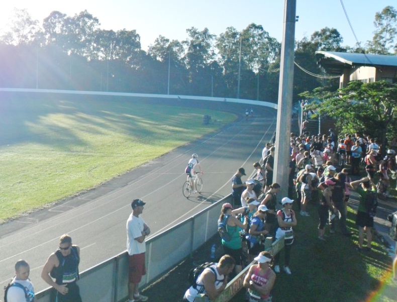
The race start/finish line is at the Nerang velodrome. 


The course is predominantly on hilly 4WD fire trails and covers the last section of the 96km Kokoda Challenge in July.

The sun had risen and was bathing the grounds with bright sunlight. Runners trickled in but suddenly swelled as the start time at 0700h approached.

The cyclists had to wait at the sidelines as the runners took the velodrome centre stage for a few minutes.


Pre-race instructions.


Then they were off.


The course was indeed narrow and rough and hilly and challenging and I enjoyed every moment of it, well except for the running part.  It was single file for the first kilometre of the course. Runners bunched up at the pipe fence on entry to the forest trail. Many were slowed down but I wasn’t too fussed, this was a hilly 25km run, not a pleasant 2.5km sprint down along the beach. A few eager beavers did weave in and out to get up front. Eventually the runners found their pace and place on the first 2.5km gentle incline and then downhill to the 3.5km. This up and down pattern on some 10 rolling hills, is the hallmark of this Nerang state forest trail run.

We toured the second hill to the southern wye junction (4.5km) before descending down the Keith McKay Gap to Coombabah Creek at the 6km mark. Then up the third hill to Siberia then down to Saltwater Creek (8.1km). And so we hit ‘heartbreak hill’ where mere mortal runners like me were forced to walk. I looked around and everyone else seemed to follow the running adage "if you cannot see the top of the hill, walk it." No truer words have been spoken, but especially for this hill.


A couple of teenaged lads did sprint past me up the hill. Thankfully the hill wasn’t too high and then soon enough after a bit of a hike, we were descending again to another creek (Markham’s Creek). Going up from here was another steep hill (hill 5 by my count), perhaps the twin or smaller sibling of ‘heartbreak hill’ where again I was reduced to a walking zombie. Its gradient gradually lessened as we ascended up to the northern wye junction on the hilltop at 11.1km. From here it was downhill and more technical what with narrow single-file tracks covered with loose rocks and knee-high grass in parts. Then we come to a split concrete and dirt driveway before exiting the forest to a bitumen road (Holyrood Road, Maudsland) going downwards to the turnaround station and halfway checkpoint . I enjoyed this respite down the hill but dreaded the uphill return.

At running events, I naturally observe other runners and try to match it with those who can pull me along.  Throughout the first half of the run I noticed a lady in pink and two or three gentlemen who were within 100m in front of me from about the 2 to 3km point.  We sort of leapfrogged each other a couple of times, on the inclines and declines and flatlines, depending on where our strengths and weaknesses are. I gained on the ascents to the summits and they took me back on the flat grounds and downhills. 
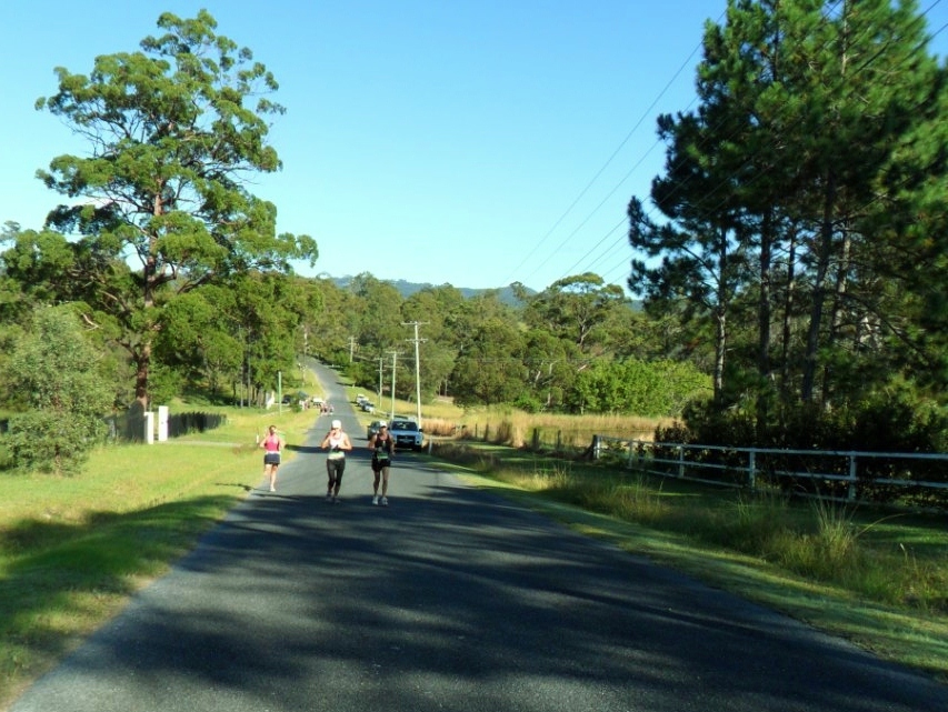
Eventually ‘pink lady’ sped away from us on the approach to the turnaround point. 

At the checkpoint I took stock, checked my water, helped myself to some fluids, rested briefly, then commenced the return leg. I had hoped to keep ms pink lady in sight, but did not see her again until I stumbled back to the finish line, some 10 minutes behind. I did a slow jog on the 2.8km uphill back to the northern wye junction, and was quite amazed when this younger man in red shirt sprinted up the hill like Usain Bolt.

From the 11km to the 13.5km I got to see many of the ultra runners on their second leg of the 50km run. Many of them were older than me but very fit and strong runners. There’s at least one gentleman there in his young late 60s, and two or three 'granny smiths' going strongly. I can only cheer them on and say ‘well done, good running’. 

The return leg was similar to the first with another five rolling hills and peaking at Macca’s corner. They were not as steep as ‘heartbreak hill’, but that’s cold comfort.

The final 2km+ was pleasantly downhill and I actually enjoyed the winding homestretch. I even caught a young man in green shirt just before the finish line. He said “oh so close...” which made me smile a bit. I said “nearly there man, keep going.” Only later did I find out that he was doing another lap just for fun. Well done young man!

Nearing midday, a straggler struggles to the finish.


And awarded with a well-earned tee-shirt.


The finish line under the shady eucalypts.


A big thank you to all involved: the organisers, the volunteers at the halfway mark and at the finish, and those behind the scenes. Great work!

There is a link to the 2012 full results at the  AURA website.

Wednesday, 4 April 2012

Workingman's Blues #12 & 4. The road to Columboola

Driving is the ideal way to tour the rural parts of Queensland. I have had the opportunity to travel parts of the outback as part of my work. A few weeks back I was asked to travel to the western downs yet again but this time my assignment is non-CSG related. Westward from Brisbane are the great agricultural regions of southern Queensland, stretching from the Lockyer valley to the Darling Downs, the western downs and beyond. The Warrego highway is the main artery for road transport to these parts, passing Ipswich, Gatton, Toowoomba, Oakey, Dalby, Chinchilla, Roma, Mitchell etc.
The lower plains of the Lockyer valley is a regular haunt too and will be back there in the times ahead. Toowoomba on a plateau is a beautiful city which I like visiting. Driving up the steep Toowoomba range often reminds me of the zigzag road ascending to Baguio from the lowlands of Saitan in La Union.To the north and northwest from Toowoomba, are many more quiet country towns set on the hills and ranges leading to the Bunya mountains. The vast expanses of the agricultural downs are situated west of Toowoomba. Gowrie mountain is the gateway to the downs.
The provincial city of Dalby is modernising at such a quick pace that older buildings are inevitably being ran over by commercial development.

Knocking on Dalby’s Austral Chambers doors. Who's that rapping at my chamber door? 'Tis no visitor' I muttered. Progress there and nothing more.
The land transport twins, highway and railway, often run side by side sometimes for hundreds or thousands of kilometres. 
Highways are the bloodlines of commerce while railways serve the resources industries. They are both vital to agriculture and pastoral farming.

Water supply is usually a little problem out here, but not in the recent two years, where record rainfalls have fallen everywhere.
I met a cartagenan hawking his fluid wares on my way to Chinchilla.
Creeks are filled to overflowing and the normally dry creek beds are proving unnavigable, like in Wambo creek.

Off Royalty Road, we did not meet kings and princes but found some flood flotsam, debris caught in barbed wire fences, tens of meters above the rivers and creeks. These are indications of the extent and height of flooding.
Fences on the high banks have become drying lines for weeds and debris caught on the wires as the floods raged past. In the same place, life goes on as birds continue to build their nests - with the grass debris.

Who’s that dragging the chain? Heavy duty giant chains used for land clearing.

The impact of land clearing, utilising an enormous heavy-duty chain between two bulldozers, resulted in the deforestation of extensive tracts of bushland all around Queensland. This method was championed by former premier Bjelke-Peterson. What a legacy. The remaining brigalow belt and eucalypt woodlands of central Queensland was reported to have received improved protection from further clearing. So what's doing with this chain?

Paying homage by leaving a token by the gatepost. The electric post bears witness, i mean bears a cross.


Driving along the Warrego Highway on the west of Chinchilla, this traveller came by Cameby, or at least the signpost to Cameby. I did not visit there but saw Old Cameby Road.
The miles and miles of dirt roads around Miles are a car trap in wet weather. Once after some rains, I drove down this 8km dirt road off Old Cameby Road, and just kept going and going as I could not turn around for the soft shoulders. I was about 5km in when I considered reversing, but had second thoughts. The car struggled all the way at about 15kph for about half an hour, before I sighted the dirt terminating on a beautiful bitumen road (never thought of bitumen as beautiful before this).
I was almost there but for a short 50m section of deep mud in a pool of water. I hopped out, waded through and with a stick prodded and probed looking for the firmer ground underfoot. Then I reversed back another 50m, accelerated in the mud and thankfully got through the boghole in the middle of nowhere. 


Another day we had to turn back from Greenswamp as Charleys creek had turned into a raging torrent. 
Overnight rains have flooded the roads. 
Farther downstream, the floodwaters threatened a bridge on the western outskirts of Chinchilla. This bridge flooded a couple of times before in early 2011. This time the waters came up short and we got through to Columboola.


Whilst in the dry, big cattle trucks come rumbling along with noise and dust.

Bones of some recently departed bovine off Kogan-Condamine road. Victim of the drought? Or perhaps a snake or illness? 

On the way back from Chinchilla to Brisbane, I opted for the backroads through Jandowae, Bunya Mountains, Maidenwell then back on the D'Aguilar Highway.
Jandowae is situated just outside coal seam gas development areas, its population in danger of decline.

Magnificent rainforests cover most of the Bunya Mountains.
Schoolkids have marked out their campsites on an end-of-schoolyear excursion.


We stopped at the cafe for directions to Timbuktu. Just follow the road apparently-
and your nose too.
We also lingered on the lookout for a bit of awe-inspiring natural grandeur. Bunya Mountains is home to the world's largest stand of ancient bunya pines. They're now protected under national park status, but who knows what will happen when progress comes knocking, or when the climate change times are a-changing.

Come evening we reluctantly head down one of the steep and winding mountain roads back to civilization and progress.
The pretty tiny town of Maidenwell is home to an astronomical observatory. Will visit here again.


Back on familiar roads, and I still prefer the out of the way mountain roads such as Mt Mee Road.
And Clear Mountain Road overlooking Lake Samsonvale.
Hey, what about Columboola? 

Saturday, 31 March 2012

Cliff2cliff fat ass 2012

Cliff2cliff (Shorncliffe to Redcliff)  25 March 2012.
About 80 runners turned up for this fat ass (no fee and informal) running event. The events listed are: 50km ultra,Marathon and Half-marathon 
The foreshores of Moreton bay along the northern coastal villages of Shorncliffe Sandgate Brighton in Brisbane and the bayside suburbs from Clontarf to  Scarborough in the Redcliff peninsula are picturesque and beautiful recreational areas comprising beaches jetties and piers parklands picnicking grounds swimming pools and other features all linked by tree-lined pathways with more than enough facilities including toilets drink fountains barbeques exercise structures sculptures and other art pieces etc.
Shorncliffe, Sandgate and Brighton on Moreton Bay.
Oh yes i come not to praise
the place, but to race
an event called the cliff2cliff
hoping to place, not in last place
or fall off the cliff face
and come to grief... 

anyone know poetry?

A half-marathon is a test of sorts. It is a test of endurance and speed, if one’s aiming to see how fast she can run. Marathoners and ultra runners may scoff at what I call endurance, and the speed freaks go past me as if i’m standing still, but it’s the business end of a funrunner’s diary – exam time. Nothing personal against endurance and speed but my aim is to finish and at a reasonable time (somewhere faster than walking).
Night was still wrestling with the dawn when i arrived, but it soon yielded to the glorious bright sunlit morning which greeted the runners at the Shorncliffe pier. Actually I slept in and was amongst the last to arrive. The race director Grant came ronning er running to put me down for the 50km ultra. I asked to register for the 211km super-ultra, but apparently that event was cancelled. The boardwalk on the pacific coast around Moreton and Stradbroke Islands to Kingscliff in NSW was still under construction J, so I had to settle for the 21.1km half-marathon.

A sunrise or sunset meander along the beautiful foreshores from Shorncliffe to Brighton and beyond the bridge to Redcliff is worth doing. And if something is worth doing, then it is worth doing well. So I thought why walk when you can fly? And indeed I went up to the skies to capture the incomparable beauty of these parts of the northern Brisbane area.
Shorncliffe
From cliff to cliff and park to park, jetty to jetty and bridge to bridge, its all here. Yes even creek to creek, bay to bay, 'fish and chips' shops to 'chips and fish chops', all the way from coast to coast...
Too much waffling Martin. Back to running.

A good number of runners had turned up. In the few weeks and days leading up to the race, there was a bit of chatter in the coolrunning forum for this fat ass event, so many more were attracted to its features. Cooled by the seabreezes off moreton bay and shaded and protected by trees lining the coast, the sometimes winding but mostly straight pathways take runners for a tour of the foreshores.
Last year’s inaugural cliff2cliff was a leisurely run with fewer participants, but this year’s looked a serious race for many of the faster runners out front.

Sandgate by the sea.
Shorncliffe is the mustering area for this great fat ass running event. The name Shorncliffe derives from the appearance of its headland as viewed from out on Moreton Bay. It is also the starting area for the Brisbane to Gladstone Easter yacht race, and that's coming up soon, but before that are the runners.
At the gun, the runners headed south to the groyne fronting the Shorncliffe headland cliffs, a 300-350m route alteration due to ongoing repairs to the pier. We ducked in and out of trees and bollards and sidestepped around tables and lawns on the short out and back trip to the groyne. Then the race settled to its rhythm.
From the start I ran, or tried matching paces with a self-trained runner, Ms Chelle, a young woman who starts her day with a lazy early morning run of 'only' 9km. And as if that's not enough, she also does another easy 9 km home in the evenings.
We hit Sandgate at about the 2km mark. Sandgate is popular for excursions and picnics and outings, but since the opening of the Hornibrook Highway to the beaches in Redcliff, became more a secret hideaway for the locals. The runners toured its long foreshore reserves while taking in the panoramic views of the bay. Chelle and me ran along the lovely shady picnic lawns and foreshores. We overtook a few runners as we admired the remaining historical sights of Sandgate village.
Looking south to Decker Park in Brighton.
Brighton on the shores of Bramble Bay, lies between Sandgate and the  Houghton Highway and Ted Smout Bridge across to Redcliffe. At about the 5km mark we set foot on Brighton with its wide streets and renovated timber homes fronting the waterfront esplanades with parks, paths, restaurants, cafes and swimming pool facilities.  The seaside location and the many amenities has attracted many families to live here. 
Soon we get to the ramp and pathways of the 3km long Ted Smout bridge. 
Ted Smout Bridge on Bramble Bay at the Pine river.
The easterly wind was blowing and cooled us as we ran over the thrice-bridged waters of bramble bay on the mouth of pine river. We met many cyclists walkers and joggers on our journey from cliff to cliff. 
We were about three-quarters of an hour into the race and I had used up my water and feeling thirst. Thankfully we had in sight the inviting sprawling oasis of Clontarf with its bayside parks walkways and bikeways and recreational facilities. Clontarf at 9km mark is another charming seaside suburb at the southernmost tip of Redcliff Peninsula with a children's playground area, and popular boat ramp. I kept an eye out for the mini half-marathon turn-around marker in Pelican Park (named in honour of the amazing sea birds living in the area).
My running companion is a very fit lady, having lost a bit of weight and is now just running recreationally to keep herself slim, and dare i say dangerous. Hey Ms Pfieffer, you rule! She kindly paced me for more than half of the half-marathon, before i begged off pretending to look for a water tap.
The rest of the run was the reverse of the northbound out run. So I sailed against the southerly/ southeasterly headwind as I retraced my steps. I stopped a couple of times for water. I passed some runners, and other runners passed me. Running's like that - tit for tat.

Photos post-race.
Admiring the seascape in the sun's wake behind the clouds.
That's a newbie, I think his name's Mate, and his friend Tanker.
A couple of tourists take pictures while a barefooted finisher contemplates buying shoes,
or a camera.


A fast-finishing first timer conquers the cliff2cliff foreshores.
Ms Chelle rules!
A group does a post-race debriefing.
The rails hold firm against... pushers.
There’s a lot more features in Redcliff with Norfolk pines and swimming lagoons and beaches and picnic parks and lookout points. And in Brighton and Sandgate are local wetland reserves for native flora and fauna. There are also numerous restaurants, cafes, and of course fishing.  I do see those attractions on my occasional travels to the peninsula, via the tourist route along the coast, not by air, not on foot, but by car.