Driving is the ideal way to tour the rural parts of
Queensland. I have had the opportunity to travel parts of the outback as part
of my work. A few weeks back I was asked to travel to the western downs yet
again but this time my assignment is non-CSG related. Westward from
Brisbane are the great agricultural regions of southern Queensland, stretching
from the Lockyer valley to the Darling Downs, the western downs and beyond.
The Warrego highway is the main artery for road transport to these parts,
passing Ipswich, Gatton, Toowoomba, Oakey, Dalby, Chinchilla, Roma, Mitchell
etc.

Water supply is usually a little problem out here, but not in the recent two years, where record rainfalls have fallen everywhere.
 I
met a cartagenan hawking his fluid wares on my way to Chinchilla.
I
met a cartagenan hawking his fluid wares on my way to Chinchilla.
 Creeks are filled to overflowing and the normally dry
creek beds are proving unnavigable, like in Wambo creek.
Creeks are filled to overflowing and the normally dry
creek beds are proving unnavigable, like in Wambo creek.

 Fences on the high banks have become drying lines for
weeds and debris caught on the wires as the floods raged past. In the same place, life goes on as birds continue to build their nests - with the grass debris.
Fences on the high banks have become drying lines for
weeds and debris caught on the wires as the floods raged past. In the same place, life goes on as birds continue to build their nests - with the grass debris.
Who’s that dragging the chain? Heavy duty giant chains used for land clearing.

 Paying homage by leaving a token by the gatepost. The electric
post bears witness, i mean bears a cross.
Paying homage by leaving a token by the gatepost. The electric
post bears witness, i mean bears a cross.

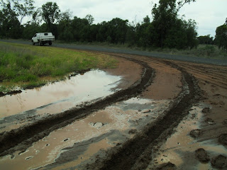
 I was almost there but for a short 50m section of deep mud in a pool of water. I hopped out, waded through and with a stick prodded and probed looking for the firmer ground underfoot. Then I reversed back another 50m, accelerated in the mud and thankfully got through the boghole in the middle of nowhere.
 Another day we had to turn back from Greenswamp as Charleys creek had turned into a raging torrent.
 Overnight rains have flooded the roads.
 Farther downstream, the floodwaters threatened a bridge on the western outskirts of Chinchilla. This bridge flooded a couple of times before in early 2011. This time the waters came up short and we got through to Columboola.
 Whilst in the dry, big cattle trucks
come rumbling along with noise and dust.
Whilst in the dry, big cattle trucks
come rumbling along with noise and dust.

 Jandowae is situated just outside coal seam gas development areas, its population in danger of decline.
 Magnificent rainforests cover most of the Bunya Mountains.


 We stopped at the cafe for directions to Timbuktu. Just follow the road apparently-
and your nose too.
 We also lingered on the lookout for a bit of awe-inspiring natural grandeur. Bunya Mountains is home to the world's largest stand of ancient bunya pines. They're now protected under national park status, but who knows what will happen when progress comes knocking, or when the climate change times are a-changing.

 Come evening we reluctantly head down one of the steep and winding mountain roads back to civilization and progress.
 The pretty tiny town of Maidenwell is home to an astronomical observatory. Will visit here again.
 Back on familiar roads, and I still prefer the out of the way mountain roads such as Mt Mee Road.
 And Clear Mountain Road overlooking Lake Samsonvale.
Hey, what about Columboola?
The lower plains of the Lockyer valley is a regular haunt
too and will be back there in the times ahead. Toowoomba on a plateau is a
beautiful city which I like visiting. Driving up the steep Toowoomba range
often reminds me of the zigzag road ascending to Baguio from the lowlands of
Saitan in La Union.To the north and northwest from Toowoomba, are many more
quiet country towns set on the hills and ranges leading to the Bunya mountains.
The vast expanses of the agricultural downs are situated west of Toowoomba.
Gowrie mountain is the gateway to the downs.
The provincial city of Dalby is modernising at such a
quick pace that older buildings are inevitably being ran over by commercial
development.
 Knocking on Dalby’s Austral Chambers doors. Who's that rapping at my chamber door? 'Tis no visitor' I muttered. Progress there and nothing more.

The land transport twins, highway and railway, often run
side by side sometimes for hundreds or thousands of kilometres.
 Highways are the bloodlines
of commerce while railways serve the resources industries. They are both vital
to agriculture and pastoral farming.
Highways are the bloodlines
of commerce while railways serve the resources industries. They are both vital
to agriculture and pastoral farming.


Water supply is usually a little problem out here, but not in the recent two years, where record rainfalls have fallen everywhere.


Off Royalty Road, we did not meet kings and princes but found some flood flotsam, debris caught in barbed wire fences, tens of meters above the rivers and creeks. These are indications of the extent and height of flooding.

Who’s that dragging the chain? Heavy duty giant chains used for land clearing.

The
impact of land clearing, utilising an enormous heavy-duty chain between
two bulldozers, resulted in the deforestation of extensive tracts of bushland
all around Queensland. This method was championed by former premier
Bjelke-Peterson. What a legacy. The remaining brigalow belt and eucalypt
woodlands of central Queensland was reported to have received improved
protection from further clearing. So what's doing with this chain?


Driving along the Warrego Highway on the west of Chinchilla, this traveller came by Cameby, or at least the signpost to Cameby. I did not visit there but saw Old Cameby Road.
The miles and miles of dirt roads around Miles are a car trap in wet weather. Once after some rains, I drove down this 8km dirt road off Old Cameby Road, and just kept going and going as I could not turn around for the soft shoulders. I was about 5km in when I considered reversing, but had second thoughts. The car struggled all the way at about 15kph for about half an hour, before I sighted the dirt terminating on a beautiful bitumen road (never thought of bitumen as beautiful before this).


Bones of some recently departed bovine off Kogan-Condamine road.
Victim of the drought? Or perhaps a snake or illness?
On the way back from Chinchilla to Brisbane, I opted for the backroads through Jandowae, Bunya Mountains, Maidenwell then back on the D'Aguilar Highway.
On the way back from Chinchilla to Brisbane, I opted for the backroads through Jandowae, Bunya Mountains, Maidenwell then back on the D'Aguilar Highway.


Schoolkids have marked out their campsites on an end-of-schoolyear excursion.


and your nose too.


Hey, what about Columboola?
No comments:
Post a Comment
please leave a comment.