The Mountain Trail or Halsema Highway linking Bontoc to Baguio opened in 1930.
From Bontoc the Dalbago Road winds southerly -
All along the southbound odyssey, the trail pulls out of Balili...
Then Gonogon, and then Sabangan. Here the Dalbago Road becomes the D'Albagosa Highway.
Rolls along past houses farms and fields... and bridges.
You've probably seen and heard all these before, so I won't ramble for much longer.
There's also a branch of the Rural Bank of Sabangan in Sagada, methinks.
Martin, thou doth wonder too much.
I know a better viewpoint of Kalawitan, from up in Chonglian.
If only I took photos...
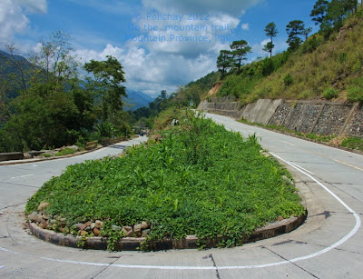
The 9th wonder of the world. When I saw this, I did a double-take. On the U-turn. Then looked again, for the second time around.A vegetable plot in the middle of the Halsema national highway in Sabangan. Only on the Mountain Trail...
We were driving through Pingad, and my tagalog friend with a lisp said:
"iwahan mo yong aho ha kalhada."
Kalawitan as seen from Pingad vantage.
But nothing beats the view from Mainit. Vintage.
Welcome to Bauko.
Maba-ay. Please buy as you come by.
Every day is market day in this town.
On the Internet, they say that the Mountain Trail is one of the world's most dangerous roads. Maybe.
Perhaps.
I do know it's one of the most scenic, terrifying thrilling, winding roads that I've seen.
It's also among the highest, and through the steepest of cliffs.
This here ain't fake, or AI made. This is the real deal.
Many more interesting places and attractions of the mountain trail are off the main road.
They are well worth your time. Just ask these monitors.
Travelers checking out accommodations on Mt Data lodge. This government-owned establishment is probably the highest hotel in the Philippines. The importance of marketing is somehow lost with the denudation of the mountain, and fading with the wear and tear on the building, and the sign.
Yes, and do come again.
The journey continues...

+(2).jpg)
+(2).jpg)
+(2).jpg)
+(2).jpg)
+(2).jpg)
.jpg)
+(2).jpg)
+(2).jpg)
+(2).jpg)
.jpg)
.jpg)
+(2).jpg)
+(2).jpg)
+(2).jpg)
+(2).jpg)
+(2).jpg)
+(2).jpg)
+(2).jpg)
.jpg)
.jpg)
.jpg)
+(2).jpg)
.jpg)

.jpg)
.jpg)


+(1280x1046).jpg)
.jpg)
+(1280x884).jpg)
+(1280x985).jpg)
.jpg)
+(1280x990).jpg)
+(1280x984).jpg)
+(1280x966).jpg)
+(1280x960).jpg)
+(1280x990).jpg)
+(1280x1055).jpg)
+(1280x1035).jpg)
.jpg)
+(1280x1007).jpg)
+(1280x995).jpg)
.jpg)
+(1280x1051).jpg)
.jpg)
+(1280x970).jpg)
+(1280x975).jpg)
.jpg)
+(1280x981).jpg)
.jpg)
+(1280x1016).jpg)
.jpg)
+(1280x963).jpg)
+(1280x993).jpg)
.jpg)
+(1280x1015).jpg)
+(1280x1026).jpg)
.jpg)