Working travels and travails.
So we proceeded on to Eidsvold then Thangool and finally arrive in Biloela in Banana shire.
I spent the next three weeks in the Banana-Gladstone regions.
While in Banana, we ranged out to Cracow, Theodore, Banana and Biloela our base.
Gladstone (named after William Gladstone, a 19th century British Secretary of State for the Colonies) is in Central Queensland, bounded by the Coral Sea in the east, the Bundaberg and North Burnett Regional Council areas in the south, the Banana Shire in the west, and the Rockhampton Regional Council area in the north.

Some of the places we visited in the Gladstone area include:


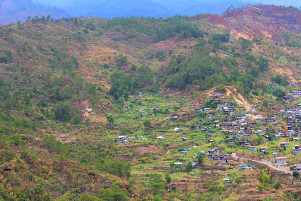
The density is well under one person per hectare but this may well change with the boom in the coal seam gas industry. Virtually all the pipelines converge in Gladstone. Other industries include an alumina refinery and smelter, a power station and port facilities.

The peripheral rural land is used mainly for cattle grazing, with some grain growing, fodder cropping, and timber and tropical fruit production.
The Gladstone council is serviced by the Bruce Highway, the Dawson Highway, major Roads and the North Coast Line of the Brisbane to Cairns railway.

This is vaguely familiar. I did do time working on the railways here in Gladstone. That was when I was young, before I dreamt of highways. Now I’m a highwayman again.

Over many long days and longer weeks, we drove through many long and lonesome highways, and many rough and dusty byways.


Across mountain ranges and hill and dale.
Through barbed wire and electric fences and tall grasses, rocky paddocks and pasturing bullocks, kangaroos and wild dogs, cockatoos and snakes. I will be posting some images of the amazing wildlife that I saw here.
From sunup to sundown, I toiled for pay for my day. One more dollar and I'm goin' home.
A three-week stint is long enough for non-stop work, 10-12 hour days. I was totally knackered, so I retreated.
After another quick stop in Gayndah for my travelling companion to have a cigarette, we got back in the state forests of the south burnett. We stopped yet again in Goomeri, for driver changeover and some coffee and cake with cream and cherry. I am starting to unlike these stops.
Amidst some grazing cattle on a green hillside, the sight of three sizeable antlered red deer scampering up a rocky ridge is quite a privilege. I hope they're not feral.
The south Burnett area has some of the richest farmlands in Australia. It now produces 95% of duboisia in the world.The peanut capital of Australia is in Kingaroy.


Three weeks and 5,000 kilometres. Good I had some music for company in the country.
I need a break.
Some few weeks ago I travelled to Biloela in central queensland for yet another out-of-town work stint. I planned a bit of an itinerary to take in some of the sights of central and southeast Queensland. This working stint will allow some driving through the regional councils of Moreton Bay, Somerset, South Burnett and North Burnett, while doing some work in Banana and Gladstone. I did go bananas before.
Travel day was a fine day, great for driving. Some clouds floated overhead keeping the temperatures down. Following familiar roads and places, we started up the Bruce Highway to Caboolture, thence turned off D’Aguilar Highway through the small towns Wamuran, D’Aguilar and Woodford. The Moreton Bay area offers a wide array of recreation leisure and entertainment activities in natural settings from beach resorts to rural mountain bays and rivers.
Soon we sight Kilcoy and Moore on the northern outskirts of Somerset region. The Somerset is a destination for a relaxing retreat, bed-and-breakfast or farmstay, camping, rail trail hiking or riding, wineries water sports and activities or sky diving. Apparently you can do it all here.
It is normally a pleasant experience but driving up the blackbutt range we got caught behind roadworks below Benarkin. Benarkin is the gateway to the south burnett from moreton.
It is normally a pleasant experience but driving up the blackbutt range we got caught behind roadworks below Benarkin. Benarkin is the gateway to the south burnett from moreton.
The South Burnett is located atop Australia's Great Dividing Range directly west of the Sunshine Coast. The region is different, really different - to the coast, or virtually anywhere else in the Sunshine State. The region and its charming towns beg to be explored. Now why wouldn’t one do exactly that?

In Nanango I bought peanuts from a peanut van under some spreading gum trees. I stayed in this town before for work in nearby Blackbutt. This town (4th oldest town in Queensland) in the green grassed meadows and rail trails of the South Burnett is at the junction of the D’Aguilar hwy and Burnett hwy. We zoom past Nanango, Goomeri and the Tansey turnoff to the coast, and thence into North Burnett.
Straddling an area of almost 20,000 square kilometres and a population of around 10 600, the North Burnett region includes the townships of Eidsvold, Gayndah, Monto, and Mundubbera and many villages and farming catchments.The region takes its name from the Burnett River that was named after surveyor "Burnett", one of the early explorers. Settlement occurred in 1848 with sheep stations and later cattle and eventually agriculture.The climate is pleasant sub-tropical though frosts and sub-zero temperatures occur in winter between June and August.
 |
| Binjour seems worth exploring but I blinked and missed it. Don't you blink too, or you'll miss this caption. Eyesight test. Only on this blog. |
 |
| We stopped in Munduberra for lunch and coffee. The royal hotel beckoned but can’t drink and drive, might spill the drink. |
Banana, a progressive shire of opportunity in Industry, Business and Tourism, is inland from Gladstone and the city of Rockhampton, the beef capital of Australia. Along with these two coastal centres, Banana is a vital hub in the boom industrial centres of central queensland. The Shire derives its name from a renowned huge dun coloured bullock named 'Banana', a legendary decoy for leading wild cattle to pens. Coal mining, beef production, power generation, dryland cropping and irrigation cropping such as lucerne and cotton are the Shire's major industries. It is rich in natural resources, with extensive undeveloped coal deposits and abundant supplies of coalbed methane gas. The Biloela meatworks is the third largest in Queensland and processes meat for export throughout Australia, Asia and around the western Pacific region.
 |
| A motel room. Home for a few weeks. |
While in Banana, we ranged out to Cracow, Theodore, Banana and Biloela our base.
 |
| The Cracow pub is famous for tent boxing. I fronted up one lazy lunchtime, but no one else did. So I settled for a glass of milk. |

Some of the places we visited in the Gladstone area include:
 |
| Calliope is inland from Gladstone. A great rest stop. |

 |
| Mt Alma |


 |
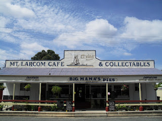
| Mount Larcom. |
 |
| Targinie. |
 |
| Yarwun. |

The peripheral rural land is used mainly for cattle grazing, with some grain growing, fodder cropping, and timber and tropical fruit production.
The Gladstone council is serviced by the Bruce Highway, the Dawson Highway, major Roads and the North Coast Line of the Brisbane to Cairns railway.

This is vaguely familiar. I did do time working on the railways here in Gladstone. That was when I was young, before I dreamt of highways. Now I’m a highwayman again.

Over many long days and longer weeks, we drove through many long and lonesome highways, and many rough and dusty byways.

 |
| From burning bush to burning mountains. |

Across mountain ranges and hill and dale.
 |
| Across rivers creeks and meadow. |
Through barbed wire and electric fences and tall grasses, rocky paddocks and pasturing bullocks, kangaroos and wild dogs, cockatoos and snakes. I will be posting some images of the amazing wildlife that I saw here.
 |
| We met many a friendly dog or horse or rabbit or kangaroo? |
 |
| And many a hostile gate or two. |
From sunup to sundown, I toiled for pay for my day. One more dollar and I'm goin' home.
 |
Twas still dark when we hit the road again on the return trip. On the Burnett Highway, some low-lying mist and cloud suspension escorted us down our way. We had breakfast under a lean-to in Monto. Later we paused for smoko at a truck stop near Munduberra.
 |
| The big orange. |
Amidst some grazing cattle on a green hillside, the sight of three sizeable antlered red deer scampering up a rocky ridge is quite a privilege. I hope they're not feral.
The south Burnett area has some of the richest farmlands in Australia. It now produces 95% of duboisia in the world.The peanut capital of Australia is in Kingaroy.

We catch a glimpse of lake Barambah.

Purchase more peanuts in Nanango (the first town established here in the south burnett). Nanango derives from the aboriginal word “noogoonida” meaning “watering hole.” At Yarraman i was in two minds whether to take the new England hwy via Toowoomba and the darling downs or the shorter way. The car voted with its shaky wheels so we rolled on down the D’Aguilar Highway.

The roadworks delays at Blackbutt range took even longer this time.
And so we leave the south burnett for now. Next time i’ll go off the beaten track to places in the region’s west and explore more of the roads less travelled around the bunya mountains through to the western downs in southern queensland. For now we take the turnoff to Esk Valley Highway.
And so we leave the south burnett for now. Next time i’ll go off the beaten track to places in the region’s west and explore more of the roads less travelled around the bunya mountains through to the western downs in southern queensland. For now we take the turnoff to Esk Valley Highway.

Soon we come to the little village of Harlin on the hills. The place invited me to stop but I kept going as i know Harlin wouldn’t run, and I’m going back to Harlin.

So on past Toogoolawah,

thence Esk, then the quite full Wivenhoe dam, to a fuel stop in Fernvale for the final leg of the trip. So on to the Warrego Highway and the Ipswich Motorway and then the busy freeways to home.

thence Esk, then the quite full Wivenhoe dam, to a fuel stop in Fernvale for the final leg of the trip. So on to the Warrego Highway and the Ipswich Motorway and then the busy freeways to home.
Three weeks and 5,000 kilometres. Good I had some music for company in the country.
I need a break.