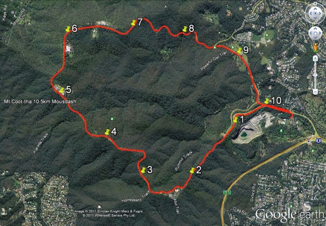
2011 Mousdash 13 November
I 'counted' at least a thousand people (700 runners, 200 walkers, and 100 teams) who converged on mt coot-tha botanic gardens for the 3rd mousdash 10.5km run and 5km walk.
It was a fine morning, warming up to a typical late spring/early summer day in November in Brisbane. Runners with their attire are a colourful enough bunch, but the addition of walkers, and the teams event, and supporters give an extra lift to the 'keeping fit' spirit. The place was buzzing with excitement and anticipation.
The third running of the Mousdash - a 10.5 km run up and down Mt Kuta. Is a great way to finish the 2011 running calendar.
I described the race route before (2010 mousdash) but briefly:The first 2.75 section of the run is the hardest. It is all uphill, with an average gradient of just under 10%. This is exactly like running up to Mt Sto Tomas, or Camp 6 to BGH in Baguio-Benguet in the mountainous Philippine Cordillera. The next section (3km to 6.5km) is along the road snaking through about a half-dozen picnic parks under the gum trees of the rolling ridges of kuta, home to the various television stations. The third section (6.5km to 8.5km) is all downhill. The final 2km flat has one more tricky little climb.
I 'counted' at least a thousand people (700 runners, 200 walkers, and 100 teams) who converged on mt coot-tha botanic gardens for the 3rd mousdash 10.5km run and 5km walk.
It was a fine morning, warming up to a typical late spring/early summer day in November in Brisbane. Runners with their attire are a colourful enough bunch, but the addition of walkers, and the teams event, and supporters give an extra lift to the 'keeping fit' spirit. The place was buzzing with excitement and anticipation.
The event has grown again in numbers this year (15% increase in runners) and looks to be a fixture in the running calendar for the next few years.
We congregated under the palms at the carpark.
The event ‘ran’ smoothly, except for a few minutes delay at the start, and also a lack of toilet amenities, which was maybe part of the delay. A race official even suggested to runners to help 'water' the trees and plants in the gardens.
Some put a bit of effort into growing a 'mo for this year's movember dash. Others just faked it.
And then they were off.
I definitely did not run smoothly, but many of the others did. I’m amazed how they sprint up the mountain and sustain good speed to the finish. The top 10 placegetters finished in under 40 minutes and a great number (the first 100) under 50 minutes. The faster half (first 340-350) finished in just under one hour which is very good going for this route. I managed to not go under my age which is -I don’t know - a good thing or a pity. Good that i’m not that old, or a pity that i’m so slow, so I’m told. Not that I need reminding. The results were promptly posted by the event timers. I believe photos are available for purchase.
I took some candid ones pre-race.
The race was last weekend, when i was on a break from working in central queensland. While on away work i had precious little training for any running event let alone mt coot-tha. But I had grown a stubble on my dial to pass off for a 'tash.
Twas early last Sunday morning, i fronted up at the mt coot-tha botanical gardens with not much expectation. Having joined a few funruns I knew where to take my place - near the back. The net time was to be adjusted from the gun time, but like last year, this did not happen.
Twas early last Sunday morning, i fronted up at the mt coot-tha botanical gardens with not much expectation. Having joined a few funruns I knew where to take my place - near the back. The net time was to be adjusted from the gun time, but like last year, this did not happen.
Last year I parked on a grassy verge of a sidestreet under the purple splash of a spreading jacaranda tree. I did so again this time but had to get in really early.
I described the race route before (2010 mousdash) but briefly:The first 2.75 section of the run is the hardest. It is all uphill, with an average gradient of just under 10%. This is exactly like running up to Mt Sto Tomas, or Camp 6 to BGH in Baguio-Benguet in the mountainous Philippine Cordillera. The next section (3km to 6.5km) is along the road snaking through about a half-dozen picnic parks under the gum trees of the rolling ridges of kuta, home to the various television stations. The third section (6.5km to 8.5km) is all downhill. The final 2km flat has one more tricky little climb.


No comments:
Post a Comment
please leave a comment.